Satellites & Bleaching
Composites and Animations
|

|

|

|
|
|
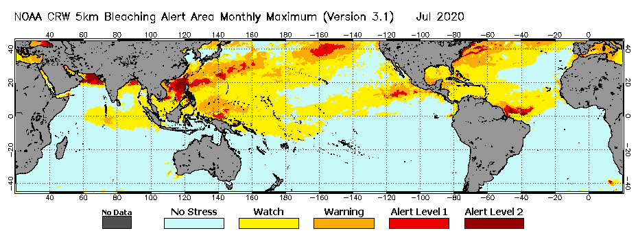
Shown here is an example Monthly Composite map image, for July 2020, of the Maximum Global 5km Satellite
Coral Bleaching Alert Area product. This map image displays the maximum
Bleaching Alert Area
heat stress level (No Stress, Bleaching Watch, Bleaching Warning, Alert Level 1, or Alert Level 2) that was experienced at
locations all over the world for the month of July. Click the image to view a larger version.
|

|
|
NOAA CRW offers Year-to-Date (for the current year), Monthly, and Annual Composites of the main daily global 5km satellite coral bleaching heat stress
monitoring products discussed in this tutorial. These include: Sea Surface Temperature (SST),
SST Anomaly, Coral Bleaching HotSpot,
Degree Heating Week (DHW), and Bleaching Alert Area.
Maximum composites are available for all of these products. Minimum and mean composites are available only for the SST and SST Anomaly products because
the Coral Bleaching HotSpot, DHW, and Bleaching Alert Area are positive-value-only products. You can access the composite data files and map images on
the Composites page of the CRW website.
CRW also provides the most recent 30-Day and 90-Day Animations of its daily global 5km SST,
SST Anomaly, Coral Bleaching HotSpot,
DHW, Bleaching Alert Area, and
SST Trend products. These animations are accessible on the
daily global 5km satellite coral bleaching heat stress monitoring products data page,
as well as on each of the stand-alone pages on the CRW website for the aforementioned products.
(top)